本站所有转载资源全部来源于本站会员,仅供下载学习与参考,请勿用于商业用途,下载学习试用后请于24小时内删除,如有条件请支持正版,如有侵权请联系删除,谢谢。
资源介绍
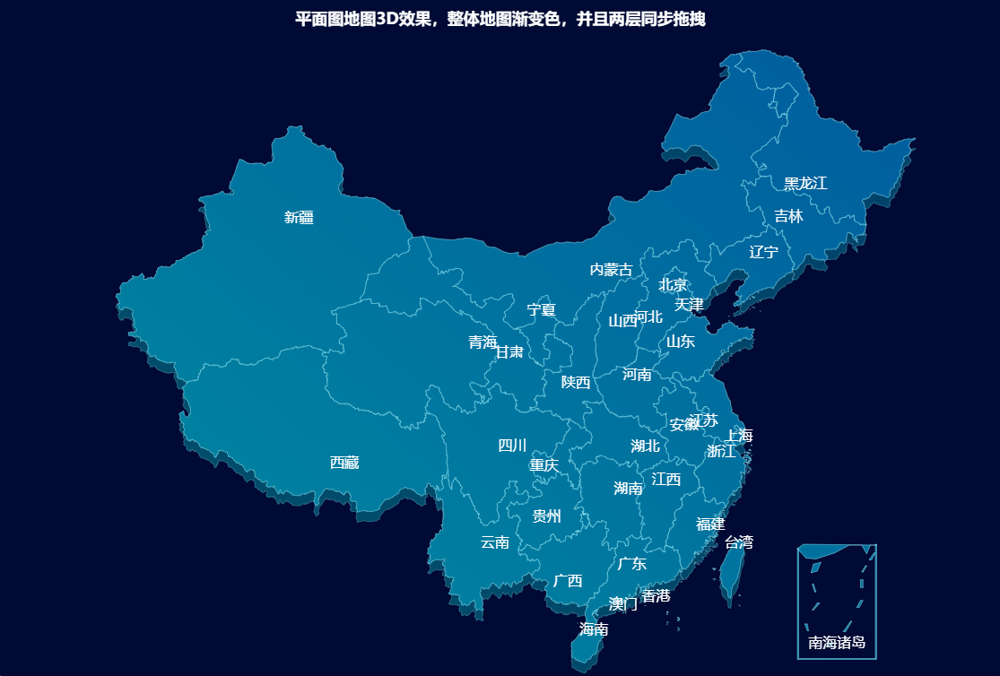
一、通用组件使用方式
1. 引入依赖
<!DOCTYPE html>
<html>
<head>
  <meta charset="utf-8">
  <meta name="viewport" content="width=device-width">
  <title>地图-平面图地图3D效果</title>
</head>
<body>
<div id="chart" style="width: 100%;height:100%;"></div>
<script src="http://cdnjs.cloudflare.com/ajax/libs/echarts/4.8.0/echarts.min.js"></script>
<script src="http://39.101.138.43:8090/wp-content/themes/wpzt-hot/echarts/map/js/china.js"></script>
</body>
</html>
2. 绘制图表
var myChart = echarts.init(document.getElementById('chart'));

var option;

option = {
    title: {
        top: 10,
        text: '平面图地图3D效果,整体地图渐变色,并且两层同步拖拽',
        left: 'center',
        textStyle: {
            color: '#fff'
        }
    },
    backgroundColor: 'rgba(0, 10, 52, 1)',
    geo: {
        map: 'china',
        aspectScale: 0.75,
        layoutCenter: ["50%", "51.5%"], //地图位置
        layoutSize: '118%',
        roam: true,
        itemStyle: {
            normal: {
                borderColor: 'rgba(147, 235, 248, 1)',
                borderWidth: 0.5,
                color: {
                    type: 'linear-gradient',
                    x: 0,
                    y: 1500,
                    x2: 2500,
                    y2: 0,
                    colorStops: [{
                        offset: 0,
                        color: '#009DA1' // 0% 处的颜色
                    }, {
                        offset: 1,
                        color: '#005B9E' // 50% 处的颜色
                    }],
                    global: true // 缺省为 false
                },
                opacity: 0.5,
            },
            emphasis: {
                areaColor: '#2a333d'
            }
        },
        regions: [{
            name: '南海诸岛',
            itemStyle: {
                areaColor: 'rgba(0, 10, 52, 1)',
                borderColor: 'rgba(0, 10, 52, 1)'
            },
            emphasis: {
                areaColor: 'rgba(0, 10, 52, 1)',
                borderColor: 'rgba(0, 10, 52, 1)'
            }
        }],
        z: 2
    },
    series: [{
        type: 'map',
        map: 'china',
        tooltip: {
            show: false
        },
        label: {
            show: true,
            color: '#FFFFFF',
            fontSize: 16
        },
        aspectScale: 0.75,
        layoutCenter: ["50%", "50%"], //地图位置
        layoutSize: '118%',
        roam: true,
        itemStyle: {
            normal: {
                borderColor: 'rgba(147, 235, 248, 0.6)',
                borderWidth: 0.8,
                areaColor: {
                    type: 'linear-gradient',
                    x: 0,
                    y: 1200,
                    x2: 1000,
                    y2: 0,
                    colorStops: [{
                        offset: 0,
                        color: '#009DA1' // 0% 处的颜色
                    }, {
                        offset: 1,
                        color: '#005B9E' // 50% 处的颜色
                    }],
                    global: true // 缺省为 false
                },
            },
            emphasis: {
                areaColor: 'rgba(147, 235, 248, 0)'
            }
        },
        zlevel: 1
    }]
};


//echarts 设置地图外边框以及多个geo实现缩放拖曳同步
myChart.on('georoam', function(params) {
    var option = myChart.getOption(); //获得option对象
    if (params.zoom != null && params.zoom != undefined) { //捕捉到缩放时
        option.geo[0].zoom = option.series[0].zoom; //下层geo的缩放等级跟着上层的geo一起改变
        option.geo[0].center = option.series[0].center; //下层的geo的中心位置随着上层geo一起改变
    } else { //捕捉到拖曳时
        option.geo[0].center = option.series[0].center; //下层的geo的中心位置随着上层geo一起改变
    }
    myChart.setOption(option); //设置option
});

myChart.setOption(option);
3. 生成的Option配置
{
	"title": {
		"top": 10,
		"text": "平面图地图3D效果,整体地图渐变色,并且两层同步拖拽",
		"left": "center",
		"textStyle": {
			"color": "#fff"
		}
	},
	"backgroundColor": "rgba(0, 10, 52, 1)",
	"geo": {
		"map": "china",
		"aspectScale": 0.75,
		"layoutCenter": ["50%", "51.5%"],
		"layoutSize": "118%",
		"roam": true,
		"itemStyle": {
			"normal": {
				"borderColor": "rgba(147, 235, 248, 1)",
				"borderWidth": 0.5,
				"color": {
					"type": "linear-gradient",
					"x": 0,
					"y": 1500,
					"x2": 2500,
					"y2": 0,
					"colorStops": [{
						"offset": 0,
						"color": "#009DA1"
					}, {
						"offset": 1,
						"color": "#005B9E"
					}],
					"global": true
				},
				"opacity": 0.5
			},
			"emphasis": {
				"areaColor": "#2a333d"
			}
		},
		"regions": [{
			"name": "南海诸岛",
			"itemStyle": {
				"areaColor": "rgba(0, 10, 52, 1)",
				"borderColor": "rgba(0, 10, 52, 1)"
			},
			"emphasis": {
				"areaColor": "rgba(0, 10, 52, 1)",
				"borderColor": "rgba(0, 10, 52, 1)"
			}
		}],
		"z": 2
	},
	"series": [{
		"type": "map",
		"map": "china",
		"tooltip": {
			"show": false
		},
		"label": {
			"show": true,
			"color": "#FFFFFF",
			"fontSize": 16
		},
		"aspectScale": 0.75,
		"layoutCenter": ["50%", "50%"],
		"layoutSize": "118%",
		"roam": true,
		"itemStyle": {
			"normal": {
				"borderColor": "rgba(147, 235, 248, 0.6)",
				"borderWidth": 0.8,
				"areaColor": {
					"type": "linear-gradient",
					"x": 0,
					"y": 1200,
					"x2": 1000,
					"y2": 0,
					"colorStops": [{
						"offset": 0,
						"color": "#009DA1"
					}, {
						"offset": 1,
						"color": "#005B9E"
					}],
					"global": true
				}
			},
			"emphasis": {
				"areaColor": "rgba(147, 235, 248, 0)"
			}
		},
		"zlevel": 1
	}]
}
END
上一篇 地图-模拟3D效果-自动轮询提示
下一篇 地图-伪3D世界地图+散点图

